Scott Madry, Ph.D.
Research Associate Professor of Archaeology
Open Source GIS
 I am a long-time proponent of open source spatial analysis tools, going all the way back to 1986 when I started using the GRASS GIS (rev. 3.1) and hosting the third GRASS users conference in 1987 when I worked at the NASA Stennis Space Center. Check out this 1992 edition of the GRASSCLIPPINGS newsletter and other historical documents. I have taught many short courses and classes around the world and was on the original board of the Open GRASS Foundation, The Open GIS Foundation, and of the Open Geospatial Consortium in 1994. I continue to be active, conducting research and teaching workshops and courses around the world.
 QGIS is a recent, very easy to use and powerful GIS that has a link with GRASS, providing the ability to quickly learn and use these powerful, open source tools. I have developed over 200 pages of free QGIS/GRASS workshop materials that I freely share in my training programs. I teach short courses in QGIS and GRASS periodically at UNC through the Odum Institute , and also and around the world. If you are interested in QGIS training, feel free to contact me!
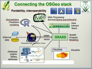
 The integrated QGIS/GRASS can run in Windows, Mac or Linux, and are parts of the powerful OSGEO Stack, that includes the R statistics package, WMS and WFS servers, etc. Visit the GRASS GIS website for more information.


Recent Comments